Updated April 4, 2019, First posted March 18, 2019
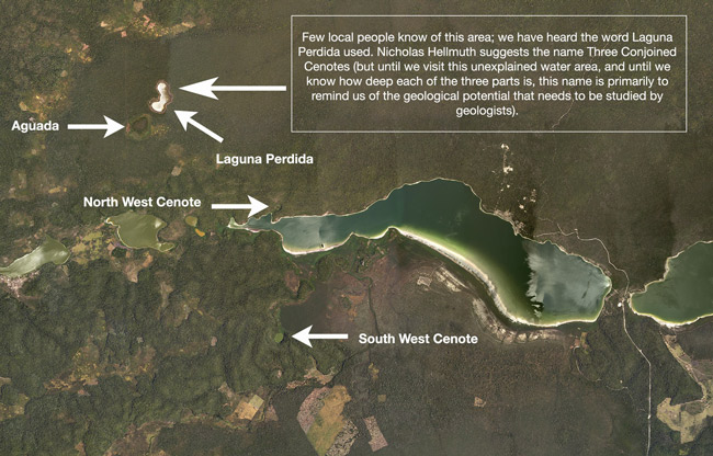
There are two well known cenote-like openings in the karst surface of the west end of Lake Yaxha. I call these the South-West Cenote and the North-West Cenote. I spell the directions as two words deliberately: both are at the west end of the lake. One is north of the lake (about 80 meters); the other is south of the lake (about 200 meters).
Both are totally filled with water (they are at the lake level; these are not like the grand cenote of Chichen Itza (where you see the water only far below)). The one cenote is between 94 and 98 feet deep, so almost 30 meters deep).
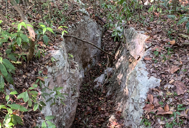
I call them a cenote because the opening is the perfect size and shape of a cenote opening (I know cenotes from childhood, in the karst area of Missouri; we have a perfect Maya style cenote behind our house: about 40 to 50 feet down into the limestone, and the water is only at the bottom (flowing in and out via a cave sprint).
Now I have discovered what I call a “Triple Conjoined Cenote” or “triple-conjoined circular lagoons” (if geologists determine they were not cenotes thousands of years ago). The triple-conjoined circular shape is visible on Google Maps (satellite view) and even more visible on aerial photographs of the Instituto Geografico Nacional (Guatemala).

If a benefactor could provide us with a Phase One digital aerial camera, Capture One software, and powerful new computer to handle the RAW images, then we could help the institute do special coverage of the parks area of Peten (LiDAR technology removes the vegetation digitally; we need to see every single tree, every bush, in a higher resolution than any satellite system or higher than any normal government system does in these remote areas.
Photos with a Phase One iXU-RS1900 Aerial Camera (the best); or at least a Phase One iXM-RS150F, would literally change our understanding of the “Mayan rain forest ecosystems.”
Kit would include iX Controller MK III with Gyro Stabilized Mounts.
Phase One Industrial, is a division of Phase One medium format camera company, Denmark.
The triple-conjoined circular lagoons are above (north of) one of the lakes (Laguna Lankaja) to the west of the west end of Lake Yaxha. There is a bog-like aguadas-like area a few meters south of the Lake of Three Cenotes. Local people call the triple conjoined lakes Laguna Perdida.
In March we hiked many hours to reach this area (led by capable park rangers Teco and Prudencio). We had to climb up a ravine from past Laguna Lankaja; climb uphill to the Laguna Perdida area. How is water this high at the top of the hill? And why are the triple-conjoined circular lagoons filled even in the dry years? (we checked Google’s 20-year set of images; water every year). Of course if there is a spring below the water pressure could force the water up, but I am obviously not a geologist. So our goal is to show this to the world and encourage geologists to measure its depth (and double-check the North-West Cenote of Lake Yaxha since one person told us “it was not very deep.”
Teco (Moises Daniel Perez Diaz), a helpful park ranger, told us about a collapsed cave that takes out water from the north edge of Lake Yaxha. So there is a lot for a geologist to study here (especially for a PhD dissertation, with the geological fault overlooking the East of Nakum Savanna a major chapter.
There may be a better geological word for these round areas; I am using the word cenote-like circular-shaped until I learn a better word.