Posted April 20, 2022, by Nicholas Hellmuth
Video of Nicholas Hellmuth discussing a previously never-before-studied biodiverse fragile ecosystem in a remote area deep in the rain forests of the Maya Lowlands of Guatemala.
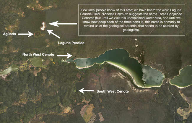
Tasistal-Savanna #30 is a savanna of about half a million tasiste palm trees, Acoelorrhaphe wrightii, in clusters forming a solid mass of palms the extent of several football fields. This is one of 35 savannas in the far southeast part of Parque Nacional Laguna del Tigre (Jaguar Lagoon National Park) of the Reserva de la Biosfera Maya (RBM). The RBM is the entire northern half of the departamento de Peten, Guatemala. FLAAR has a project of coordination and cooperation with CONAP for the RBM area.
These seasonally inundated tasistal savannas are surrounded by seasonally inundated bajo forest swamps (that we hike through in the dry season to explore the savannas).
FLAAR aerial video allows you to see from the air a part of the Maya Lowlands of Peten literally never before seen on video: Tasistal-Savannas #22, open grassland Savanna #25 and surrounding bajo forests.
How in the world were each different kind of savannas used for thousands of years by the Classic Maya. First step is to find, then explore, then document these remarkable tasistal palm areas and also the open grassland savannas.
Whatever concept you have for “the Mayan areas” will be changed when you see kilometer after kilometer in good resolution from the FLAAR drone, DJI Mavic 2 Pro, with experienced drone pilot Haniel Lopez doing the video photography.
For a quick look at never-before-studied tasistal savanna of Parque Nacional Laguna de Tigre (PNLT) of the Reserva de la Biosfera Maya (RBM), Peten, Guatemala, this video is a quick view from FLAAR (USA) and FLAAR Mesoamerica (Guatemala).
When you see this video you too will ask “how did the Classic Maya utilize these biodiverse open grassland savanna habitats? Every month we dedicate a week to driving 1000 km round trip to a base camp in the rain forest, and from the base camp we hike for many kilometers to reach a savanna in the Maya Lowlands that has never ever previously been shown on video (for sure not with a licensed drone).
Our project of Aug-2018-July 2019 (for Parque Nacional Yaxha, Nakum and Naranjo) and now our 5-year research project 2021-2025 with CONAP are to find, photograph, research, document, and publish Neotropical flora, fauna and ecosystems of the Reserva de la Biosfera Maya (RBM) of Peten, Guatemala. Lots of national parks and biotopos are within the 5-million acres of the RBM.
If you prefer FLAAR reports in pdf format on these savannas, here is the link.